|
| |
|
|
|
|
| Rugged portable
computer for AgGPS receivers
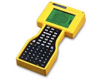 The
AgGPS® 160 Portable Computer running
AgGPS® FieldManager
software
is
the ultimate in flexible field computing. Use it as a handheld or vehicle-
mounted with a quick-release adjustable mount. Growers, crop consultants,
soil samplers, custom applicators, topographic mappers, drainage or land
leveling contractors can all benefit from the AgGPS 160 system. It
is waterproof, drop-proof and has a long battery life - you can be confident
that it will not break or lose data while you are working. It is very easy
to use in a variety of agricultural applications, saving you time and
money. The system works with Trimble AgGPS receivers and AgGPS®
Parallel Swathing Options or
AgGPS® EZ-Guide™
system for guidance. Applications include point, line, area, field boundary
and topographic mapping, soil sampling, crop scouting, sensor and bar-code
logging and application coverage logging. All data is stored in ESRI
Shapefile format for easy integration with existing agricultural data.
 | graphical sunlight readable touch screen display |
|
| waterproof and drop-proof from 4 feet (1.2 m.) |
|
| up to 40 hours battery life |
|
| full alpha and numeric keypads |
|
| field and on-the-go point, line and area mapping |
|
| soil sampling |
|
| application coverage logging |
|
|