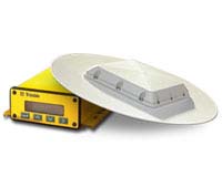
Centimeter-accurate, dual-frequency RTK receiver for guidance applications
The
AgGPS®214 High Accuracy Topographic mapping system can be
used with AgGPS MultiPlane® for design of subsurface water
management systems. The AgGPS 214 uses GPS instead of a laser
transmitter, increasing operational range in both distance and large
elevation changes. The data is collected as an ESRI shape file, a common
data exchange format, making it simple for the user to use a range of
Agricultural mapping software. AgGPS
MultiPlane
easily reads the data collected with the AgGPS 214 Topographic
mapping system.
advanced centimeter-level precision RTK receiver for high accuracy
agricultural applications
external CMR or RTCM correction input (requires a base station to
transmit high accuracy corrections)
positioning based on dual-frequency carrier phase processing