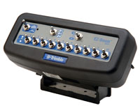
NEW! EZ-Guide 500 Lightbar Guidance System
The world's first GPS lightbar with color
display, mapping and steering capable of one-inch accuracy
The EZ-Guide® 500 represents the latest innovation in lightbar guidance
systems with a large color screen – over 300% larger than the EZ-Guide
Plus or any other lightbar on the market. The AgGPS®
EZ-Guide 500 features multiple accuracy options, and data logging function
to record data and transfer via USB flash drive for generating printed
maps and reports.
Precision dual-frequency L1/L2 GPS receiver allows
users a variety of accuracy upgrades-based on crop and operation
needs-without purchasing an external receiver:
Most of today's lightbars can't be upgraded to higher accuracy without
adding an external GPS receiver that may cost you several thousand
dollars. But a typical EZ-Guide 500 high-performance package will cost you
about 20-30% less than comparable solutions available today.
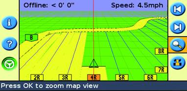
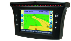
Color display on the EZ-Guide 500 system provides
graphic quality currently available only in displays twice the size and
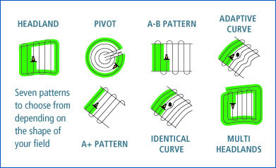
price. It offers advanced but easy-to-use guidance patterns, as well as
real-time "where-applied" mapping. The EZ-Guide 500 system also has a
built-in lightbar with 31 guidance LEDs that are highly visible even in
bright daylight.
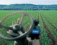
The new EZ-Guide 500 system is designed to provide GPS
positioning and graphic display for Trimble assisted steering, auto
guidance and spray rate control solutions:
 | The AgGPS
EZ-Steer®
assisted steering system can be connected to the EZ-Guide 500 system in
30 minutes and can be used on hundreds of vehicle models. |
| EZ-Guide 500 also drives the Trimble AgGPS Autopilot
automated steering system, which offers +/-1 inch repeatable accuracy.
|
| The EZ-Guide 500 is also compatible with the new Trimble AgGPS
EZ-Boom™ 2010 automated boom switching & spray rate controller system.
|
Performance highlights:
|
| Large 7-inch color display |
|
| Dual-frequency L1/L2 receiver allows a variety of accuracy upgrades
without purchasing an external receiver |
|
| Typical high-performance package built around the system will cost
you about 20 to 30% less than comparable solutions from competitors |
|
| Designed to provide GPS positioning and graphic display for Trimble
assisted steering, auto guidance and spray rate control solutions |
|
| Offers advanced the easy-to-use guidance patterns, as well as
real-time "where-applied" mapping.
|
 Field
Test Report
Field
Test Report
Before any new Trimble product is released to the market, pre-release
models undergo rugged, real-world testing and evaluation by growers
worldwide. Here are initial reactions to AgGPS® EZ-Guide® 500 from
professional agronomist Kelvin Jarvis, owner of Ag Soil Solutions in
Neepawa, Manitoba.
Trimble: What impressed you most about the EZ-Guide
500 system?
Jarvis: The big color screen and having the buttons
right on it. You can mount EZ-Guide 500 on the side window and punch
away while you're going-you don't need a remote. The other thing I liked
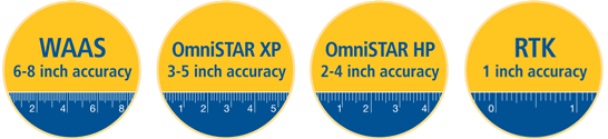
is that with accuracy upgrades, you can turn on the receiver option you
need-WAAS, OmniSTAR, or even RTK.
Trimble: How will the EZ-Guide 500 system fit your
local growers' operations?
Jarvis: I think the main benefit will be record
keeping. Let's say you have it on your sprayer-it'll record what you
did, where you did it. Traceability and proof of everything you applied
to the crop is going to become very important. That really scares some
farmers, but EZ-Guide 500 will do it for them as they're going through
the field.
Trimble: Anything else growers will like?
Jarvis: The as-applied coverage mapping. Some of
this country is very pot-holey, slewy land. They'll be able to easily
look at the map and say, " Did I miss a spot? Did I do that corner?"
Also, I think they'll like the elevation side of it. As they're going
across the field, they can save the elevations to make contour maps.
Trimble: Any surprises?
Jarvis: The USB-I was happy when I saw that. That
just makes sense and it's easy. Whether you're uploading or downloading
from your computer you can just have that information on a memory stick
for easy transfer for map or report creating.